


The UN warns of the imminent formation of an El Niño episode, a natural warming with great global impact that adds to climate change caused by human activities. And this double factor especially justifies the alert.
Read more Leonor becomes the first princess to skydive
Driven by unusually warm ocean waters in the tropical Pacific, UN climatologists have confirmed the imminent appearance of this El Niño episode, a warming that is gaining strength and will influence global temperature and precipitation patterns.
The result is an increased risk of extreme weather events in the coming months, according to the World Meteorological Organization (WMO).
Probabilities are increasing
This meteorological organization indicates there is an 80% chance that a warming event will occur between June and August 2026.
Similarly, the chances that this phenomenon will continue at least until November are above or close to 90%.
While some uncertainty remains about its intensity and peak timing, “most forecast models suggest it will be at least moderate, and possibly strong,” says the WMO.
WMO updates on El Niño are the most authoritative source of information worldwide and serve for governments, humanitarian agencies, and climate-sensitive sectors such as agriculture, health, energy, and water management to take measures to mitigate its impacts. The WMO notes it will closely monitor conditions in the coming months to support decision-making and advise governments, humanitarian agencies, and climate-sensitive sectors.
‘El Niño’ will arrive at our doorstep in the coming months with 90% certainty. The world must treat it as the urgent climate alert it is
António Guterres
UN Secretary-General
“The science is clear: El Niño will arrive at our doorstep in the coming months with 90% certainty. The world must treat it as the urgent climate alert it is. El Niño conditions will fuel the ‘fire’ of global warming,” said UN Secretary-General António Guterres in his video message.
“The impacts will be even stronger, will spread further, and will cross borders at a devastating speed. The only effective response is climate action commensurate with the crisis: ending dependence on fossil fuels, accelerating the transition to renewable energy, protecting the most vulnerable, and providing early warning systems for all,” he added.
Sea temperatures in the central and eastern equatorial Pacific
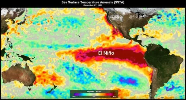
Between late April and mid-May, sea surface temperatures in the central and eastern equatorial Pacific—the area used as a reference for this monitoring—were approaching El Niño thresholds, according to observations from various platforms used by the WMO.
These unusually warm sea surface conditions in the tropical Pacific involved temperatures exceeding 6 °C above average, representing a significant heat reservoir.
Caused the 2024 temperature record
Droughts and heavy rains
“We must prepare for a possible intense El Niño, which will exacerbate drought and heavy rains, and increase the risk of heatwaves both on land and in the ocean,” said WMO Secretary-General Celeste Saulo.
Read more Feijóo speaks at the second day of the annual meeting of the ‘Cercle d’Economia’
The most recent El Niño, in 2023-24, was one of the five most intense recorded and contributed to the global temperature records we saw in 2024, Saulo added.
Continuous monitoring, formation between March and June
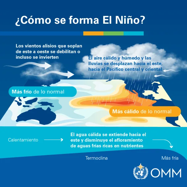
El Niño and La Niña are opposite phases of the so-called El Niño Southern Oscillation (ENSO), one of the most powerful natural climate patterns on Earth.
El Niño is characterized by warming of the ocean surface temperature in the central and eastern equatorial Pacific, usually occurring every two to seven years and lasting between nine and twelve months. La Niña is its opposite and results in cooling.
El Niño generally begins to develop between March and June and reaches its peak intensity between November and February. Its most pronounced temperature impacts occur the second year after its development.
Its effects vary
The effects of each El Niño or La Niña event vary depending on its intensity, duration, time of year it develops, and its interaction with other modes of climate variability.
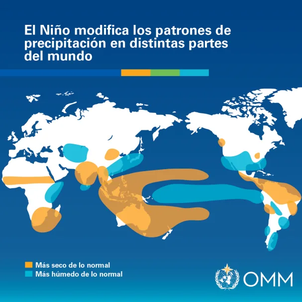
Each event of this type is unique. However, generally El Niño is associated with drier conditions in Central America, northern South America, the Caribbean, Australia, Indonesia, and parts of southern Asia, and increased precipitation in parts of southern South America, southern United States, parts of the Horn of Africa, and Central Asia.
During the boreal summer, warm El Niño waters can fuel hurricanes in the central and eastern Pacific, while hindering their formation in the Atlantic basin. Therefore, the United States National Oceanic and Atmospheric Administration (NOAA) forecasts a below-normal hurricane season for the Atlantic basin this year.
Also read
Seasonal climate update: the planet’s weather this quarter
The WMO also published a complementary global seasonal climate update that considers ENSO and other key climate factors.
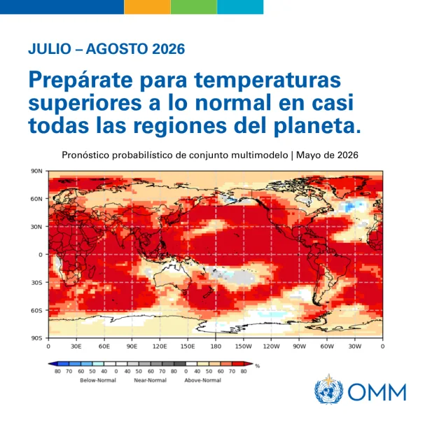
For the June to August season, “forecasts project an almost universal predominance of above-normal temperatures worldwide.” This worsens hazards in some regions and accelerates drought development where precipitation decreases.
Rainfall probabilities are typical of El Niño patterns, likely contributing to a higher likelihood of extreme events (e.g., increased rains and flooding, as well as drier conditions and droughts).
On the other hand, there is no evidence that climate change increases the frequency or intensity of El Niño events. However, it can amplify associated impacts, as a warmer ocean and atmosphere increase the availability of energy and moisture for extreme weather events such as heatwaves and torrential rains.
Read more New deadly attacks on major Ukrainian cities following Russian threats of retaliation


