


More than four hundred years ago, in 1602, the Italian missionary Matteo Ricci, together with the Chinese cartographer Li Zhizao, created the “Map of the Ten Thousand Countries of the Earth” or Kunyu Wanguo Quantu. On that map, the Ming dynasty empire was at the center of all known land. That map was on the verge of opening China’s doors to Christianity.
Read more The blogger who tells Putin that “he is being lied to”
The story of the Jesuit Matteo Ricci is fascinating. We told it a year ago in Penínsulas, shortly after the death of Pope Francisco, on the occasion of a series of articles about the conclave that was to elect his successor. Today marks one year since Francisco’s death, the world is much more turbulent, and a strong current of sympathy is building in favor of his successor. People are now paying attention to Leo XIV.
Religious language is increasingly present in public discussion. Energy, artificial intelligence, religion, and maps. These are the four cardinal points of current affairs. Geography is taking its revenge with a vengeance, overflowing the prophecy of Robert Kaplan, author in 2012 of a book titled The Revenge of Geography. The geopolitical concept is now omnipresent; the immediate future of the world economy depends on the Strait of Hormuz, radical Muslims are no longer the only ones who claim to fight in the name of God, and modern China updates its maps without abandoning the center of the world.
We must return to Ricci, therefore. Accompanied by the Spanish Jesuit Diego de Pantoja, the Italian missionary arrived in China in 1601 with a collection of European atlases that greatly interested Emperor Wanli. He asked them for a Chinese version, and the Jesuits, with the collaboration of an imperial advisor, produced an enormous world map in which China, the Middle Kingdom (Zhōngguó), appeared in the center. With this representation of the world, they earned the highest regard of the emperor, opening up the possibility of evangelizing China. Settled at the court in Beijing, Ricci wrote to Rome outlining the situation: Christianity could expand in China if the evangelical narrative was adapted to its ancient culture. God had to become the Lord of Heaven, the cult of the deceased had to be accepted, and the deification of the philosopher Confucius had to be assimilated. The deliberation lasted more than a century. Finally, when Ricci and Pantoja had been dead for years, Pope Benedict XIV ruled in 1742 that Christians could not participate in traditional Chinese rites.
The map we want to talk about today, with the collaboration of geographer Santiago Fernández Muñoz, was drawn in 2013 by the Chinese geophysicist and cartographer Hao Xiaoguang. It has the status of an official map; the President of the People’s Republic of China, Xi Jinping, is photographed with it, it has been promoted by the Central Military Commission, and it is working material for the commanders of the People’s Liberation Army. It is a map that develops the central vision of China with which the Jesuits wanted to please Emperor Wanli in the 17th century, to make clear what its geopolitical perspective is in the 21st century.
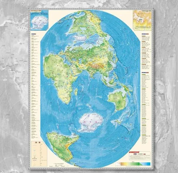
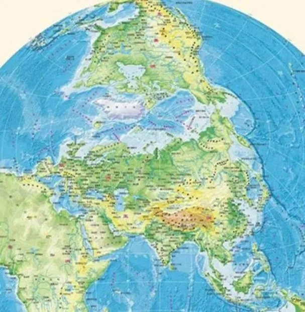
Vertical World Projection. This is a vertical map that breaks with the traditional west-east scheme, the traditional Western world map that goes from the Atlantic to the Pacific with Europe in the center, the Iberian Peninsula occupying a very visible place. The map with which we were educated in school. Our vision of the world. The map that, even today, when many current facts contradict it, makes us believe that we inhabit the Pacific Empire of the Center, the relatively pacified European confederation of the center after two terrible wars in the last century.
This Vertical World Projection allows for various interpretations and conjectures. China is at the center, and the American continent does not appear as a geographical unit, as the great World Island. North America appears at the top, and South America at the bottom. Eurasia dominates the scene with China at the visual center. China’s communication with Europe (the western arm of the great Eurasian continental platform) can be carried out by land, through Russia; by the precious Indian Ocean route (Straits of Malacca, Hormuz, and Bab el Mandeb, Suez Canal), currently plunged into a colossal military crisis; slowly circumnavigating the African continent, the old route of Portuguese navigators; or by the Arctic Ocean, if the ice permits.
It is interesting to observe the Arctic on that map. It is no longer the invisible sea of our school atlases. The Arctic is today a crucial sea for communication between the Pacific and the Atlantic if navigation conditions permit. And the melting ice already allows it for about five months a year. Let’s observe the northern Eurasian coast, forming an extensive front that goes from the Bay of Biscay to the Bering Strait, where a few miles separate the eastern tip of Russia from Alaska, United States territory since 1867, purchased from the Tsar of all Russias.
Let’s observe the North American Arctic coast and we will fully understand why the current United States government wants to annex Greenland and, in a rude manner, proposes the incorporation of Canada into the Union. Without Greenland (Denmark) and Canada, the United States only has access to the Arctic via Alaska. The United States is today a very minority partner in the Arctic, Inc. society. The main partner is Russia. China has no shares, but it does have a good alliance with Moscow, after decades of enmity despite having shared the principles of Marxism-Leninism.
The map tells us that it is of utmost interest for China to continue cultivating a good relationship with Russia, especially if we consider that the first commercial navigation routes through the Arctic run near the Russian coasts, whose waters thaw more quickly due to the tempering effect of the water that the mighty Siberian rivers discharge into the sea. On the very fragmented Canadian coast, the thaw takes longer and its waters are more complicated to navigate.
China wants Russia by its side. And the United States feels the need to soften or break that alliance. Richard Nixon and Henry Kissinger saw the rift that had opened in the 1960s between the Soviet Union and the People’s Republic of China, after the death of Stalin, and went to Beijing to try to widen it. 1972. At that time, China was riding bicycles and not drawing vertical world projections. The constant pressure of NATO on Russia’s borders after the fall of the Berlin Wall (1989) has gradually contributed to this rapprochement. In the 1960s, the USSR was the dominant friend. Now it is China. The war in Ukraine has accentuated this convergence of interests.
The Biden Administration believed that Russia’s military defeat in Ukraine would be a great warning to China. The Trump Administration wants to end the war in Ukraine as soon as possible with a strategic prize for Russia and punishment for Europe. The pincer movement of the United States and Russia on Europe is one of the great novelties of our time. It is possible that one day we will see the United States offering technological collaboration to Russia for the exploitation of natural resources in the Arctic, collaboration in the tracking of rare earths in exchange for participating in the business. History does not repeat itself, but it rhymes. Trump returns to Nixon. In his youth, Trump was a great admirer of Nixon. The United States will seek ways to soften China’s alliance with Russia. Hao Xiaoguang’s map tells us so. Whether Trump and his court of miracles manage to emulate Kissinger is another matter.
Read more The EU is already talking about defense without NATO
We continue to contemplate the Vertical World Projection. The map presents Africa almost as an annex to Eurasia. The English geographer Halford Mackinder, father of Western geopolitical theory, argued that if a single power dominated Eurasia, it would soon gain control of Africa, thus gaining control of the world. This axiom explains the terrible struggle for positions that has been waged in Africa since the end of World War II. China has been very skillful in Africa.
Let’s continue to pay attention to the African continent in the Chinese vertical projection. Africa has two physical points of contact with Eurasia: the Strait of Gibraltar and the maritime strip separating East Africa and the Arabian Peninsula: the Red Sea. While the Suez Canal was being built, Jules Verne imagined in the novel Twenty Thousand Leagues Under the Seas that there was an underground canal connecting the Red Sea and the Mediterranean.
Suez, Red Sea, Strait of Bab el Mandeb, Gulf of Aden, and the countries of the so-called Horn of Africa. This quadrant is a substantial part of the great regional battle taking place in the Middle East. Hormuz is very important. The immediate future of the world economy currently passes through the Strait of Hormuz, but the Horn of Africa quadrant is no less relevant. The Greater Israel project extends from Lebanon to Somaliland, a territory split from Somalia in 1991, a small country in the Horn of Africa, now under Israeli tutelage, from which the Strait of Bab el Mandeb can be monitored.
The struggle is for control of the Suez route. The struggle is for control of the route that transports oil and gas to Europe. Soon we will see projects to bypass Hormuz and transport hydrocarbons from the Persian Gulf across the Arabian Peninsula to reach the Mediterranean by land. If Israel’s Mediterranean ports ever become a powerful energy hub, Europe will owe it obedience. A large part of the oil and gas consumed in Europe would come from the United States and from Israeli terminals connected to the Persian Gulf. With this information, we will surely better understand the ongoing battle.
Let’s continue to pay attention to the map. The other Eurasia-Africa connection point is in Spain and, in some way, in Italy, due to its proximity to Libya from Sicily. An alternative hub could be the Iberian Peninsula, connected by pipeline to Algeria (two gas pipelines, one of them closed since 2021), a large recipient of liquefied natural gas (eight regasification plants on its coasts), a large producer of renewable energy, with strong potential for hydrogen production (future Barcelona-Marseille submarine pipeline).
The Iberian Peninsula has geopolitical importance and today presents six strong political connections: with the European Union, obviously; with North Africa, with Latin America (Lula de Silva in Barcelona, Corina Machado in Madrid, this past weekend), with the United States, despite tensions (military bases, oil and gas imports), and now with China. Pedro Sánchez‘s recent trip to China was more than just a commercial trip. For China, Spain is today a distant but interesting periphery.
We return to the Vertical World Projection. On the Chinese map, Antarctica stands out. In traditional Western maps, Antarctica does not usually appear in its entirety; it is hinted at but does not appear. Hao Xiaoguang’s map tells us that China will be very attentive when in 2048 the possibility of reviewing the Antarctic Treaty signed in 1959 opens up, an agreement that defines the great frozen continent as neutral territory, “a natural reserve devoted to peace and science.” China’s maritime connection with the South American cone passes near Antarctica.
And finally, though not least, the Pacific. China fears being encircled by the Pacific, which is why it tries to expand its territorial waters. The United States maintains a defensive forum with Japan and Australia, to which India has been added. It is called QUAD. The United States, Japan, Australia, and the United Kingdom share the AUKUS alliance. China fears being one day strangled in the very important Strait of Malacca, since Malaysia and Indonesia are, ultimately, allies of the Americans. For its part, the United States fears a military challenge from the People’s Republic of China with the reconquest of the island of Taiwan. And here we find ‘Davidson’s window’.
What window are we talking about? Many people today know about the Overton window (the framework of acceptable ideas, the ideological shift of societies), but Davidson’s window is less discussed. Admiral Philip Davidson, former head of the United States Indo-Pacific Command, warned in 2021 that China was beginning to feel militarily prepared to carry out an operation to reconquer the island of Taiwan, thanks to the development of its naval and ballistic power. Davidson spoke of a 2021-2027 window, since next year marks the centenary of the founding of the People’s Liberation Army. Other military analysts speak of the 2020-2030 period. At this moment, the United States has moved part of its naval force in the Pacific to the Indian Ocean to encircle Hormuz. Davidson’s window is wide open.
Would China be willing to expand the current international crisis with a military intervention in Taiwan? With the Strait of Hormuz at stake, there are reasons to doubt it. China has large strategic oil reserves, but ultimately it also needs Hormuz to be open. Navigation through the Arctic is still in a testing phase.
Conjectures about a map.
(This new chapter of ‘Penínsulas’ has been produced with the collaboration of Santiago Fernández Muñoz, geographer, expert in geopolitics and public policies, partner at SILO).


